Trail Walking Municipality of Agios Nikolaos - Le sommet d’Oxa à partir d’Agios Nikolaos - Photo

Le sommet d’Oxa à partir d’Agios Nikolaos

© OpenStreetMap contributors
Length
Length
21 km
Max alt
Max alt
511 m
Uphill gradient
Uphill gradient
670 m
Km-Effort
Km-Effort  
30 km
Min alt
Min alt
-1 m
Downhill gradient
Downhill gradient
670 m
Boucle
Boucle
Yes
Creation date :
2024-09-22 07:20:11.0
Updated on :
2024-09-22 12:12:21.021

(0 Reviews)

Walking
Walking
4h51
Difficulty : Very difficult

Scan this QR Code to open this trail in the SityTrail application

FREE GPS app for hiking

Logo SityTrail SityTrail

IGN / Geographical institutes

Download SityTrail from the App Store Download SityTrail from Google Play

Logo SityTrail SityTrail World

The world is yours!

Download SityTrail from the App Store Download SityTrail from Google Play Download SityTrail on Huawei AppGallery

About

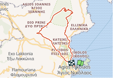
Trail Walking of 21 km to be discovered at Region of Crete, Lasithi Regional Unit, Municipality of Agios Nikolaos. This trail is proposed by wallander76.

Description

Pas toujours facile de trouver le bon itinéraire !! Les sentiers balisés sont rares et on se retrouve fréquemment face à des grillages et des grilles fermées. Le nombre de kilomètres parcourus est donc sensiblement supérieur à ce que je pensais.

Elevation profile

Photos

Positioning

Country:
Greece
Region :
Region of Crete
Department/Province :
Lasithi Regional Unit
Municipality :
Municipality of Agios Nikolaos
Location:
Unknown
Start:(UTM)
383399 ; 3894922 (35S) N.

Trails nearby

Trail Walking Municipality of Milatos - Du Minos Imprial à Sissi - Photo
Walking
wallander76

Walking

Easy
Municipality of Milatos, Region of Crete, Lasithi Regional Unit, Greece
12 km | 15.2 km-effort
2h 31min
Yes
Trail Walking Municipality of Pachia Ammos - Monastiraki  - Photo
Walking
cobut.jp@gmail.com

Walking

Very difficult
Municipality of Pachia Ammos, Region of Crete, Lasithi Regional Unit, Greece
13.6 km | 24 km-effort
4h 14min
No
Trail Walking Municipality of Lastros - L’Astrid - Photo
Walking
cobut.jp@gmail.com

Walking

Difficult
Municipality of Lastros, Region of Crete, Lasithi Regional Unit, Greece
10.9 km | 16.4 km-effort
6h 57min
Yes
Trail Walking Municipality of Pachia Ammos - Cayon du Ha - Kavousi  - Photo
Walking
cobut.jp@gmail.com

Walking

Very difficult
Municipality of Pachia Ammos, Region of Crete, Lasithi Regional Unit, Greece
19.7 km | 43 km-effort
5h 26min
No
Trail Walking Unknown - Gorge :de Messonas Kavousi  - Photo
Walking
cobut.jp@gmail.com

Walking

Very difficult
Unknown, Region of Crete, Lasithi Regional Unit, Greece
22 km | 34 km-effort
5h 58min
No
Trail Walking Municipality of Lastros - L’astronaute Voo - Photo
Walking
cobut.jp@gmail.com

Walking

Difficult
Municipality of Lastros, Region of Crete, Lasithi Regional Unit, Greece
9.9 km | 16.7 km-effort
4h 41min
No
Trail Walking Municipality of Sfaka - Scalaire toulouti - Photo
Walking
cobut.jp@gmail.com

Walking

Very difficult
Municipality of Sfaka, Region of Crete, Lasithi Regional Unit, Greece
16.3 km | 24 km-effort
6h 52min
No
Trail Walking Municipality of Elounta - spinalonga - Photo
Walking
Domdomii

Walking

Easy
Municipality of Elounta, Region of Crete, Lasithi Regional Unit, Greece
1.9 km | 2.4 km-effort
1h 43min
Yes
Trail Walking Municipality of Kato Chorion - Thripti Afendis Kavouusi - Photo
Walking
reury1948

Walking

Easy
Municipality of Kato Chorion, Region of Crete, Lasithi Regional Unit, Greece
40 km | 57 km-effort
3h 57min
No


Close
My subscriptions